Click here for details

New RECON Website Coming Soon!
Over the coming weeks will be transitioning to a brand new RECON website! The new site will still provide all of the near real-time data RECON has become known for, but it will do it in a much better capacity!
SCCF RECON
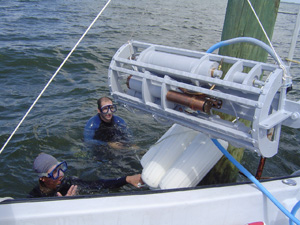
The River, Estuary and Coastal Observing Network (RECON) is a network of optical water quality sensors deployed throughout the Caloosahatchee river and estuary to provide real-time, water quality data to scientists, policy makers, and the general public. RECON's network of high-quality, autonomous, in situ sensors can detect the presence of algal blooms and nutrient hotspots.
The extensive watersheds of the Caloosahatchee (1,400 square miles) and Lake Okeechobee (4,400 square miles) each contribute water that flows into the Caloosahatchee estuary and the Gulf of Mexico. Water quality is affected by both Lake Okeechobee discharges and runoff from the Caloosahatchee watershed. Over time, these watersheds have changed from low-nutrient loading marshes and wetlands to high loading urban and agricultural land uses. Nutrients increase turbidity and decrease concentrations of dissolved oxygen (DO). In addition, excess nutrients fuel nuisance algal blooms. Losses of low-nutrient adapted communities, such as seagrasses have contributed to changes in fish, crustacean and marine mammal communities.
Tarpon Bay
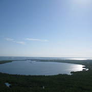
Tarpon Bay is a 930 acre estuarine water body connected to southern Pine Island Sound, located 8.5 km from Shell Point and the mouth of the Caloosahatchee River. Tarpon Bay is located within the J.N. "Ding" Darling National Wildlife Refuge (NWR) on Sanibel Island, Florida and contains one of a few marine 'wilderness' areas in the U.S. Today, a large portion of Tarpon Bay is dominated by sandflats, oyster reefs, and seagrasses. Once known for its incredible fishing (e.g., the first tarpon caught on rod and reel, c. 1885) and very healthy habitats, the quality of fishing and associated habitats are perceived to be degraded. Its bay scallop (Argopecten irradians) population has virtually disappeared. The Lab has been involved in scallop monitoring and restoration efforts in Tarpon Bay and adjacent Pine Island Sound (PIS) since 2003. The addition of this RECON station, in conjunction with water quality and seagrass research that the Lab is conducting within the Refuge, will greatly enhance our understanding of the unique aspects of the subtropical, barrier island coast.
Support for this RECON is provided by SCCF and its membership to assist with ongoing and future collaborative research efforts with J.N. "Ding" Darling National Wildlife Refuge (NWR) scientific staff and visiting researchers working with the SCCF Marine Lab.
| CDOM | QSDE | |
| Chlorophyll | µg/L | |
| Conductivity | S/m | |
| Depth | m | |
| ft | ||
| Dissolved O2 | mg/l | |
| Nitrate | µM | |
| O2 Saturation | mg/l | |
| Salinity | ||
| Temperature | °C | |
| °F | ||
| Turbidity | NTU |
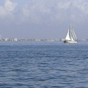
Redfish Pass
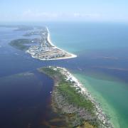
Redfish Pass to the north of Blind Pass is a deep water inlet that connects the Gulf of Mexico with Pine Island Sound, a shallow water body and Aquatic Preserve, protected by the barrier island chain. Frequent water exchanges between the Gulf of Mexico and Pine Island sound maintain clear, emerald green water that supports large visual predators such as tarpon and sharks.
John and Donna Schubert generously supported RECON at Redfish Pass.
| CDOM | QSDE | |
| Chlorophyll | µg/L | |
| Conductivity | S/m | |
| Depth | m | |
| ft | ||
| Dissolved O2 | mg/l | |
| Nitrate | µM | |
| O2 Saturation | mg/l | |
| Salinity | ||
| Temperature | °C | |
| °F | ||
| Turbidity | NTU |
 |
|
| Temperature | F | |
| Heat Index | F | |
| Wind Chill | F | |
| Humidity | % | |
| Dew Point | F | |
| Barometric Pressure | in | |
| Pressure Trend | in/h | |
| Solar Radiation | µE/m²/sec | |
| Daily Rain* | in | |
| 24 Hour Rain | in | |
| Yearly Rain | in |
Blind Pass
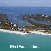
Transition of Blind Pass
Until August 2009, Blind Pass was a low or no volume inlet separating Sanibel and Captiva Islands that periodically opened naturally through storms or through dredging to connect Pine Island Sound to the Gulf of Mexico. Blind Pass is now open with dredging to continue on the Gulf of Mexico side in late 2009. The SCCF Laboratory has been funded by Florida Sea Grant and internal funding to sample prior to and after its opening (in both the rainy and dry seasons) to assess changes in water quality and seagrasses both in the Gulf and on the Pine Island Sound and Bayous side. We are also sampling the adjacent Red Fish Pass for comparison as it has been freely connecting the Gulf and Sound since a hurricane opened it in 1921.
Blind Pass historically has produced great fishing and nursery habitats in the protected waters of the lower estuary, and in the shadow of the nearby Gulf Intracoastal Waterway (GICW). Seagrass losses and coast-wide red tides have diminished productivity of these waters for larger fish, such as the spotted seatrout. With the opening of Blind Pass it is predicted to improve seagrasses and water quality in the area of the pass.
More information about Blind Pass reopening can be found here.
| CDOM | QSDE | |
| Chlorophyll | µg/L | |
| Conductivity | S/m | |
| Depth | m | |
| ft | ||
| Dissolved O2 | mg/l | |
| Nitrate | µM | |
| O2 Saturation | mg/l | |
| Salinity | ||
| Temperature | °C | |
| °F | ||
| Turbidity | NTU |
Shell Point
Shell Point, which constricts the lower tidal Caloosahatchee near the Sanibel Causeway, was once home to oyster reefs, a critical habitat for fish and crustaceans. Oysters are tolerant of large swings in salinity but cannot survive under extended periods that are either too fresh or too salty.
Salinity in the estuary has always fluctuated by season, precipitation and tides. However, unnatural, extended releases of freshwater from Lake Okeechobee or too little freshwater during the dry season severely degraded most of the oyster reefs. Restoration efforts have also been hampered by artificially excessive variability in salinity.
Deborah and John La Gorce generously supported RECON at Shell Point.
| CDOM | QSDE | |
| Chlorophyll | µg/L | |
| Conductivity | S/m | |
| Depth | m | |
| ft | ||
| Dissolved O2 | mg/l | |
| Nitrate | µM | |
| O2 Saturation | mg/l | |
| Salinity | ||
| Temperature | °C | |
| °F | ||
| Turbidity | NTU |
Fort Myers
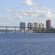
Fort Myers and Cape Coral has experienced rapid growth and urbanization in the past decade, which has dramatically affected the river and estuary. Shorelines vegetated with mangroves and marshes are populated by plants at the water's edge which can act as filters for rainwater runoff and also provide wildlife habitat. In contrast, seawalled, concrete-lined canals remove these plants along with the natural filter. This allows fertilizers and other chemicals from stormwater to run off directly into the canals, the river and the estuary. As a result water quality in the four hundred-plus miles of canals in residential neighborhoods has declined during the past decade. Another source of nutrient enrichment is septic systems built in porous sand that allow nutrients to flow into the groundwater and seep into adjacent waterbodies through the soil.
Chip and Nancy Roach generously supported RECON at Fort Myers.
| CDOM | QSDE | |
| Chlorophyll | µg/L | |
| Conductivity | S/m | |
| Depth | m | |
| ft | ||
| Dissolved O2 | mg/l | |
| Nitrate | µM | |
| O2 Saturation | mg/l | |
| Salinity | ||
| Temperature | °C | |
| °F | ||
| Turbidity | NTU |
 |
|
| Temperature | F | |
| Heat Index | F | |
| Wind Chill | F | |
| Humidity | % | |
| Dew Point | F | |
| Barometric Pressure | in | |
| Pressure Trend | in/h | |
| Solar Radiation | µE/m²/sec | |
| Daily Rain* | in | |
| 24 Hour Rain | in | |
| Yearly Rain | in |
RiverBend (the non-tidal Caloosahatchee)
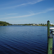
RiverBend is located 10 miles east of Franklin Lock and 36 miles east of Shell Point (about one-third of the way upriver). Franklin Lock is the artificial obstruction to salt water mixing and serves as the eastern boundary for the estuary. RiverBend is a private dock and is part of the freshwater ecosystem that makes up the Caloosahatchee watershed. Nutrients come into the Caloosahatchee from Lake Okeechobee, but the Caloosahatchee watershed is also a significant source of nutrients. Comparing the water quality data at the Moore Haven Lock (at Lake Okeechobee) and the Franklin Lock shows the amount of nutrients coming from the lake relative to nutrients from the Caloosahatchee watershed.
Agricultural land uses along the eastern Caloosahatchee watershed—including citrus, sugarcane, livestock, and ornamental nurseries—depend on the river's water for irrigation. During periods of heavy rainfall, water held for agriculture is discharged into the river, where the nutrients used to increase agricultural productivity can also cause algal blooms.
Mary Lee Dayton generously supported RECON at RiverBend.
| CDOM | QSDE | |
| Chlorophyll | µg/L | |
| Conductivity | S/m | |
| Depth | m | |
| ft | ||
| Dissolved O2 | mg/l | |
| Nitrate | µM | |
| O2 Saturation | mg/l | |
| Salinity | ||
| Temperature | °C | |
| °F | ||
| Turbidity | NTU |
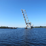
Moore Haven
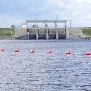
The once-natural water systems of central and south Florida have been extensively engineered to provide flood control, drinking water, water for irrigation and dry land for agriculture and development. Lake Okeechobee provides water storage for all of South Florida, but when the lake is too high, excess water is released to the Caloosahatchee and St. Lucie rivers. Freshwater discharges to the Caloosahatchee are made, here, at the Moore Haven dam, through vertical lift gates.
Nutrient loading from the lake's watershed that extends northward to Orlando, as well as back-pumping from the Everglades Agricultural Area to the south and backflowing of several canals have severely degraded the quality of the lake water. Pollution accumulated over several decades settled to the bottom of the lake. The hurricanes in 2004 and 2005 resuspended these nutrient laden sediments. When high lake levels threatened the structural integrity of the Herbert Hoover Dike surrounding the lake, this nutrient-rich water was released into the Caloosahatchee to lower lake levels.
David Lucas generously supported RECON at Moore Haven.
| CDOM | QSDE | |
| Chlorophyll | µg/L | |
| Conductivity | S/m | |
| Depth | m | |
| ft | ||
| Dissolved O2 | mg/l | |
| Nitrate | µM | |
| O2 Saturation | mg/l | |
| Salinity | ||
| Temperature | °C | |
| °F | ||
| Turbidity | NTU |
Gulf of Mexico
The Gulf of Mexico receives water from the Caloosahatchee basin, which includes water from Lake Okeechobee. Offshore reefs in the Gulf host a productive food web but these areas are particularly sensitive to excess nitrogen and phosphorus loading. The high nutrient levels carried offshore in the diluted estuarine waters have fueled the recent blooms of nuisance red drift algae.
The City of Sanibel generously supported RECON in the Gulf of Mexico.
| CDOM | QSDE | |
| Chlorophyll | µg/L | |
| Conductivity | S/m | |
| Depth | m | |
| ft | ||
| Dissolved O2 | mg/l | |
| Nitrate | µM | |
| O2 Saturation | mg/l | |
| Salinity | ||
| Temperature | °C | |
| °F | ||
| Turbidity | NTU |
 |
|
| Temperature | F | |
| Heat Index | F | |
| Wind Chill | F | |
| Humidity | % | |
| Dew Point | F | |
| Barometric Pressure | in | |
| Pressure Trend | in/h | |
| Solar Radiation | µE/m²/sec |
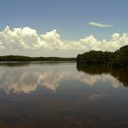
Beautiful Island
At Beautiful Island, the River broadens and there are broad, shallow areas which are suitable for submersed angiosperms such as tape grass and widgeon grass. These plants are food for manatees and are an important habitat for juvenile estuarine species of fish, juvenile blue crabs, and estuarine clams Rangia cuneata and Polymesoda caroliniana. This area is also where the dry season estuarine turbidity maximum (ETM) exists. The turbidity maximum areas are important for development of larval fish and zooplankton. Because of the removal of submarine groundwater flow, salinities in this area are often too high for the fauna and flora such as tapegrass, that inhabit the area, and supplemental flows from Lake Okeechobee are presently necessary to preserve this important habitat. Hypoxia is also a yearly occurrence in this area partly because of the stratification that develops when runoff begins to flow out over the denser, too-salty water.
David Lucas generously supported RECON at Beautiful Island.
Its replacement following a 2015 catastrophic lightning strike was made possible by donations from 86 generous donors.
| CDOM | QSDE | |
| Chlorophyll | µg/L | |
| Conductivity | S/m | |
| Depth | m | |
| ft | ||
| Dissolved O2 | mg/l | |
| Nitrate | µM | |
| O2 Saturation | mg/l | |
| Salinity | ||
| Temperature | °C | |
| °F | ||
| Turbidity | NTU |
McIntyre Creek
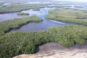
Serving as the principle tidal creek flushing the J.N. "Ding" Darling National Wildlife Refuge, the mouth of McIntyre Creek is a pivotal location for determining the effects of local and regional processes on seagrasses, mangroves, and other protected species within one of the few designated marine wilderness areas in the U.S.. Abundant food and protection from predators make tidal creeks ideal nursery grounds. With seasonally staggered life histories, larvae from various species including brown shrimp, seatrout, groupers, and mangrove snapper enter these creeks, mature and move into the Gulf of Mexico and deeper water. On the ebb tide, however, large predators, herons, and egrets lurk at the creek mouths and feed on the smaller organisms flushed from the mangroves. This location is ideal for determining the effects of large regulated freshwater discharges from the Caloosahatchee River on the Refuge.
Maintenance of this site is funded by the USFWS, J.N. "Ding" Darling National Wildlife Refuge cost-share cooperative agreement No. 401819G571
| CDOM | QSDE | |
| Chlorophyll | µg/L | |
| Conductivity | S/m | |
| Depth | m | |
| ft | ||
| Dissolved O2 | mg/l | |
| Nitrate | µM | |
| O2 Saturation | mg/l | |
| Salinity | ||
| Temperature | °C | |
| °F | ||
| Turbidity | NTU |
Moore Haven Lock (S77)
This site is part of the South Florida Water Management District data collection service (DBHYRDO). Data items are integrated into the RECON site. SCCF is not responsible for the collection or accuracy of data from this site.
The once-natural water systems of central and south Florida have been extensively engineered to provide flood control, drinking water, water for irrigation and dry land for agriculture and development. Lake Okeechobee provides water storage for all of South Florida, but when the lake is too high, excess water is released to the Caloosahatchee and St. Lucie rivers. Freshwater discharges to the Caloosahatchee are made, here, at the Moore Haven dam, through vertical lift gates.
Nutrient loading from the lake's watershed that extends northward to Orlando, as well as back-pumping from the Everglades Agricultural Area to the south and backflowing of several canals have severely degraded the quality of the lake water. Pollution accumulated over several decades settled to the bottom of the lake. The hurricanes in 2004 and 2005 resuspended these nutrient laden sediments. When high lake levels threatened the structural integrity of the Herbert Hoover Dike surrounding the lake, this nutrient-rich water was released into the Caloosahatchee to lower lake levels.
DBHYRDO Keys: Flow DJ235, Rain 16415
| Daily Rain | in | |
| Flow | cfs |
W.P. Franklin Lock (S79)
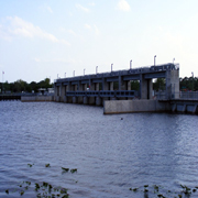
This site is part of the South Florida Water Management District data collection service (DBHYRDO). Data items are integrated into the RECON site. SCCF is not responsible for the collection or accuracy of data from this site.
DBHYRDO Keys: Flow DJ237, Rain 16414
| Daily Rain | in | |
| Flow | cfs |
Wave Buoy
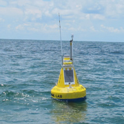
The buoy is located 2.5 miles west of Blind Pass in the Gulf of Mexico.This offshore site is capable of measuring, wave height and period, wind speed and direction, surface current speed and direction, as well as air temperature and barometric pressure.
Data collected here is important for monitoring events such as red tide or other harmful algae blooms. By knowing the wind speed/direction in combination with surface current speed and direction, scientists can forecast and track where the blooms may be going. Wave height and period will be helpful in terms of organisms washing up on our beaches: when the wave action is heavy, things that are normally attached to the bottom - such as red drift algae or pen shells - can break loose and wash ashore.
This site was funded by a grant from the West Coast Inland Navigation District.
 |
|
| Wave Height | ft | |
| Maximum Wave Height | ft | |
| Wave Period | s |
Defintions
Roll over any measurement to see a brief definition.
Click the measurement name for a detailed definition.
Temperature
Temperature can affect the distribution of marine animals. It is also important because it can influence water chemistry. It is reported here in Centigrade.
Salinity
Salinity is a measurement of the amount of salt in water. It is reported in Practical Salinity Units (psu).
Chlorophyll
Chlorophyll is the green photosynthetic pigment found in most plants, algae, phytoplankton, and cyanobacteria. It is reported here in the number of micrograms per one liter of water.
Depth
Depth reported here is the depth of the water above the sensor. This changes as a result of the tides. The sensor is suspended off of the bottom so as the tides go up and down the amount of water above the sensor changes.
CDOM
Colored Dissolved Organic Matter gives clear water various shades of tea color. Picture a fresh cup of tea with nothing else added–that color is from (CDOM). It is reported here in standardized units.
Dissolved Oxygen
Dissolved Oxygen (DO) is the amount of dissolved oxygen in water. It is reported here in the number of milligrams of oxygen per one liter of water.
Nitrate
Nitrate is an inorganic substance/nutrient essential for the growth and development of photosynthetic organisms. It is reported here in micromoles.
Oxygen Saturation
Oxygen saturation is the maximum amount of oxygen which can be retained in water without loss to the atmosphere. It is reported by SCCF RECON as the number of milligrams of oxygen per one liter of water.
Conductivity
Conductivity is the amount of electrical current that can be carried by water. It is reported here in Siemens per meter.
Turbidity
Turbidity is a measure of the degree to which light is scattered by suspended particulate material. It is reported here in nephelometric turbidity units (NTUs).
Current Heading
Current Heading is the direction the water is flowing. It is reported as a magnetic compass bearing.
Current Velocity
Current Velocity is the speed at which the water is flowing. It is reported here in meters per second.

For more information or to make a donation Click here