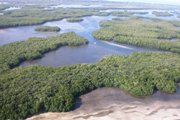
 Serving as the principle tidal creek flushing the J.N. "Ding" Darling National Wildlife Refuge, the mouth of McIntyre Creek is a pivotal location for determining the effects of local and regional processes on seagrasses, mangroves, and other protected species within one of the few designated marine wilderness areas in the U.S.. Abundant food and protection from predators make tidal creeks ideal nursery grounds. With seasonally staggered life histories, larvae from various species including brown shrimp, seatrout, groupers, and mangrove snapper enter these creeks, mature and move into the Gulf of Mexico and deeper water. On the ebb tide, however, large predators, herons, and egrets lurk at the creek mouths and feed on the smaller organisms flushed from the mangroves. This location is ideal for determining the effects of large regulated freshwater discharges from the Caloosahatchee River on the Refuge.
Maintenance of this site is funded by the USFWS, J.N. "Ding" Darling National Wildlife Refuge cost-share cooperative agreement No. 401819G571
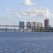 Fort Myers and Cape Coral has experienced rapid growth and urbanization in the past decade, which has dramatically affected the river and estuary. Shorelines vegetated with mangroves and marshes are populated by plants at the water's edge which can act as filters for rainwater runoff and also provide wildlife habitat. In contrast, seawalled, concrete-lined canals remove these plants along with the natural filter. This allows fertilizers and other chemicals from stormwater to run off directly into the canals, the river and the estuary. As a result water quality in the four hundred-plus miles of canals in residential neighborhoods has declined during the past decade. Another source of nutrient enrichment is septic systems built in porous sand that allow nutrients to flow into the groundwater and seep into adjacent waterbodies through the soil.
Chip and Nancy Roach generously supported RECON at Fort Myers.
The Gulf of Mexico receives water from the Caloosahatchee basin, which includes water from Lake Okeechobee.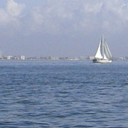 Offshore reefs in the Gulf host a productive food web but these areas are particularly sensitive to excess nitrogen and phosphorus loading. The high nutrient levels carried offshore in the diluted estuarine waters have fueled the recent blooms of nuisance red drift algae.
The City of Sanibel generously supported RECON in the Gulf of Mexico.
 At Beautiful Island, the River broadens and there are broad, shallow areas which are suitable for submersed angiosperms such as tape grass and widgeon grass. These plants are food for manatees and are an important habitat for juvenile estuarine species of fish, juvenile blue crabs, and estuarine clams Rangia cuneata and Polymesoda caroliniana. This area is also where the dry season estuarine turbidity maximum (ETM) exists. The turbidity maximum areas are important for development of larval fish and zooplankton. Because of the removal of submarine groundwater flow, salinities in this area are often too high for the fauna and flora such as tapegrass, that inhabit the area, and supplemental flows from Lake Okeechobee are presently necessary to preserve this important habitat. Hypoxia is also a yearly occurrence in this area partly because of the stratification that develops when runoff begins to flow out over the denser, too-salty water.
David Lucas generously supported RECON at Beutiful Island.
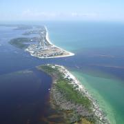 Redfish Pass to the north of Blind Pass is a deep water inlet that connects the Gulf of Mexico with Pine Island Sound, a shallow water body and Aquatic Preserve, protected by the barrier island chain. Frequent water exchanges between the Gulf of Mexico and Pine Island sound maintain clear, emerald green water that supports large visual predators such as tarpon and sharks.
John and Donna Schubert generously supported RECON at Redfish Pass.
Shell Point, which constricts the lower tidal Caloosahatchee near the Sanibel 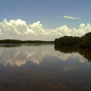 Causeway, was once home to oyster reefs, a critical habitat for fish and crustaceans. Oysters are tolerant of large swings in salinity but cannot survive under extended periods that are either too fresh or too salty.
Salinity in the estuary has always fluctuated by season, precipitation and tides. However, unnatural, extended releases of freshwater from Lake Okeechobee or too little freshwater during the dry season severely degraded most of the oyster reefs. Restoration efforts have also been hampered by artificially excessive variability in salinity.
Deborah and John La Gorce generously supported RECON at Shell Point.
 Tarpon Bay is a 930 acre estuarine water body connected to southern Pine Island Sound, located 8.5 km from Shell Point and the mouth of the Caloosahatchee River. Tarpon Bay is located within the J.N. "Ding" Darling National Wildlife Refuge (NWR) on Sanibel Island, Florida and contains one of a few marine 'wilderness' areas in the U.S. Today, a large portion of Tarpon Bay is dominated by sandflats, oyster reefs, and seagrasses. Once known for its incredible fishing (e.g., the first tarpon caught on rod and reel, c. 1885) and very healthy habitats, the quality of fishing and associated habitats are perceived to be degraded. Its bay scallop (Argopecten irradians) population has virtually disappeared. The Lab has been involved in scallop monitoring and restoration efforts in Tarpon Bay and adjacent Pine Island Sound (PIS) since 2003. The addition of this RECON station, in conjunction with water quality and seagrass research that the Lab is conducting within the Refuge, will greatly enhance our understanding of the unique aspects of the subtropical, barrier island coast.
Support for this RECON is provided by SCCF and its membership to assist with ongoing and future collaborative research efforts with J.N. "Ding" Darling National Wildlife Refuge (NWR) scientific staff and visiting researchers working with the SCCF Marine Lab.
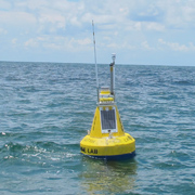
The buoy is located 2.5 miles west of Blind Pass in the Gulf of Mexico.This offshore site is capable of measuring, wave height and period, wind speed and direction, surface current speed and direction, as well as air temperature and barometric pressure.
Data collected here is important for monitoring events such as red tide or other harmful algae blooms. By knowing the wind speed/direction in combination with surface current speed and direction, scientists can forecast and track where the blooms may be going. Wave height and period will be helpful in terms of organisms washing up on our beaches: when the wave action is heavy, things that are normally attached to the bottom - such as red drift algae or pen shells - can break loose and wash ashore.
This site was funded by a grant from the West Coast Inland Navigation District.